Luisa Cardenas
University of Otago
Joe Cooper


Keep this story going! Share below!
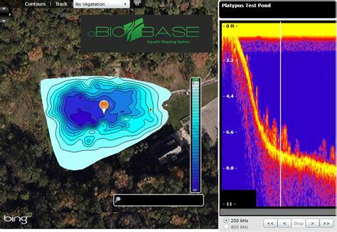
BioBase is a revolutionary technological innovation helping aquatic and marine researchers investigate and understand what is underwater in addition to assisting the development of global frameworks to protect our oceans. BioBase is a cloud-based mapping platform that takes off-the-shelf data files from consumers using sonar and GPS systems, processing raw signals and GPS locations to create maps. It is a fantastic innovation for identifying, researching, and protecting the life below the water while taking climate action.
Ray Valley found a way to understand and protect what we can now see underwater; as referenced by his catchphrase while presenting the innovation: "We cannot protect what we do not know."
Ray Valley, a co-founder of BioBase, worked for the Minnesota Department of Natural Resources (DNR) in the US in the early 2000s and spent years researching methods to use sonar technology to map fish habitats. At that time, there was no sonar technology to study the oceans in the way we could study the trees' landscapes, so he was determined to get a "fish's-eye view".
During his work as Researcher Aquatic Biologist, he was contacted by two entrepreneurs doing similar research, mainly developing inexpensive technology for anglers to create their own water maps. Rob left his job with the DNR to join the entrepreneurs in a firm called Contour Innovations, where the three of them worked in a basement in a suburban area of Minneapolis. Biobase was launched in 2012.
The BioBase innovation (UN SDG Goal 9) is a cloud-based automated data processing application that enables the quick production of maps of aquatic habitats using sonar records from echo sounders and data from satellite photos, enabling the swift gathering of high-quality data. The sound signals, how they bounce off the bottom and the depth are interpreted by kriging geostatistical algorithms that process the signal. They will inform what type of vegetation is underwater or if it's bare bottom, and in the last case, its hardness. The collected information creates a uniform map of predicted aquatic-plant biovolumes that can be shared with other partners or used for research purposes. With BioBase, it is possible to “see” what is underwater and develop frameworks to protect life from climate change and water pollution (UN SDG Goal 13). At the same time, more research is being conducted to deeply understand this aqua-landscape and the connection between species and their habitat (UN SDG Goal 14).
Ray was inspired to investigate and know the underwater world while interning with Dr. Ray Newman at the University of Minnesota. His job was doing research on the Eurasian watermilfoil, an invasive plant. He spent his summers scuba diving in Eurasian watermilfoil beds. He was amazed and fascinated by the complex underwater world and the submerged forests and "seeing how the fish related to the aquatic plants, like how the birds related to trees in a forest." This interest led to his experiments by looking at the architectural structure of aquatic plants.
In the early 2000s, Ray began his career with the DNR in the US, doing fisheries research work focusing on aquatic plants, fish, and lake ecology. That intensified his fascination with shallow lake environments' mysterious and complex underwater world. As the sonar technology was not yet developed for his work, Ray had to teach himself geo statistics, hydrics, and the fundamentals of hydro-acoustics to get the data he wanted for his fisheries research.
Currently, the inspiration continues and keeps growing. With this scientific instrument, people can now have a clear picture of the amazing and fascinating environment that is in the underwater world. In Ray's own words, most of his motivation came and keeps coming from being part of "democratising previous inaccessible water maps that is now automated and empowering biologists and researchers that want to understand more and protect the aquatic environment with low-cost technology to be able to make a bigger impact".
From 2012, when BioBase was developed, until recently, its growth was slow and steady. But now, it is definitely getting more attention. In 2022 the Federal, State, and Local governments used BioBase to map 665 waterbodies and over 356,966 cumulative acres in 32 US states and 13 Countries. In 2021, it was used in 26 US states and 10 countries.
Aquatic biologists, environmental researchers, and governmental organisations use BioBase, which is owned by Navico Group and run by C-MAP, as a platform to monitor long-term changes in vegetation density, water quality, and bottom hardness. According to Ray, “Navico Group provides free BioBase memberships to universities, nonprofits, and environmental agencies involved in the management and investigation of aquatic resources in an effort to advance the goals of aquatic conservation by maximising its access”.
BioBase has been used multiple times in different global research initiatives to control the large quantity of hostile, submerged aquatic plants, primarily in perturbed systems. One of the main reasons for its use is the relatively low cost of technology, incorporating automated hydro-acoustic methods used for mapping aquatic plant abundance and performing "before-after" evaluations of aquatic plant management.
The future application of BioBase in research will impact the marine world significantly. Currently, there is a partnership with the 11th Hours Racing and the Ocean Hour, a community of surfers, sailors, scientists, and ocean enthusiasts whose objective is to use the force of sport to restore the relationship between people and the planet. A BioBase kit will be given away to all organisations to join them.
"BioBase is currently the crown jewel of the Group" as its purpose is 100% sustainability. Brunswick acquired Navico Group in 2021 primarily for consumer mapping technology, but BioBase grew steadily and organically. However, since 2019, when the company's sustainability mission was developed, BioBase has become the star product, giving the company immense visibility and allowing it to create a sustainability team for the whole Group.
BioBase has given passion to the Group and to its employees. It has helped to show internally and externally the importance of protecting the environment. The Group is committed to measuring and evaluating its positive and negative impact regarding how it cares for its people and its responsibilities for the communities in which it works, including stakeholders such as its suppliers and its employees.
Thanks to BioBase, the company launched another mapping product called Genesis. Genesis is the consumer version of BioBase, and it's basically a stripped-down base for consumers or anglers to upload their sonar, log their records on their lands, and create their own custom depth map. These records feed a company's social map, which gets almost 100,000 downloads a year from people across the globe. The information received from the anglers goes to a central database with information on water temperature, surface temperature, vegetation for bottom hardness, maximum depth, and average depth. This data is shared with researchers so they can investigate the status and trends of habitats and lakes and how climate change is affecting them.
As Ray mentioned during our interview, we probably "know more about Mars than what we know about our oceans". This innovation has provided a tool for researchers to be able to see what is in our waters and investigate the life, ecosystems, and the interconnections between different underwater habitats. To say you were investigating was one thing, but more concrete, thanks to BioBase, is actually being able to see specific proof of what species are underwater, how they relate to another, and how climate change is impacting the ocean and its species.
Many of the areas where BioBase is used are environmentally sensitive. Using this technology allows accurate and detailed maps, which allow the possibility of developing proper treatments that will suit the type of plants beneath a specific surface. Before the existence of BioBase, researchers used to drive in a grid pattern, check the depth finder, and mentally adjust for the tide. They needed a way to put electronics on the boat as a simple way to run a route and build a map because the process for gathering data was inconsistent.
BioBase is also used as a safety tool to map weekly the sand in the harbor entrance in Santa Cruz Harbor, California. Due to natural factors, channel markers are removed throughout the winter; thus, BioBase maps are posted as frequently as possible to the website to aid boats in staying safe in the channel while arriving. The maps also warn of the likelihood of shallow conditions for individuals with deeper draught vessels.
Get stories of positive business innovations from around the world delivered right to your inbox.
Ray Valley, PRODUCT MANAGER – AQUATIC CONSERVATION
![]()
The Navico Group provides navigational, nautical, and fish-finding equipment to the commercial and recreational marine industries. Its Recreational Marine Division is one of the biggest suppliers of recreational electronic marine products. Bringing together the most reputable companies in the world for the past 20 years, The Navico Group offers decades of experience in creating and producing cutting-edge product solutions.