Nate Roller
Vincent Lam
Sebastian Cigarran
Tiffany Williams
Kendall Liu

Loyola Marymount University
Jeff Thies


Keep this story going! Share below!
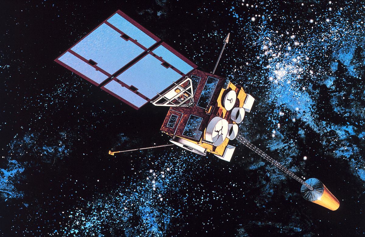
Lockheed Martin’s innovation enhances the GEOS satellite system to provide faster and more accurate real-time monitoring of weather and environmental conditions. This business solution supports UN Global Goals 9 and 13 by improving disaster response, climate tracking, and early warning systems that help protect communities and reduce environmental damage. Through advanced satellite technology, Lockheed Martin contributes to safer cities and a more resilient response to climate change.
The innovation being highlighted is Lockheed Martin’s work on enhancing the GEOS (Geostationary Earth Orbiting Satellite) system, which is designed to provide continuous, real-time monitoring of Earth’s atmosphere and surface. This project is worked on by satellite engineers and builders like Frank Roller within Lockheed Martin’s Space Systems division and has been advancing through the early 2020s as climate-related disasters have become more severe. The satellites are positioned in geostationary orbit above the equator, allowing them to remain fixed over specific regions and constantly observe the same areas without interruption.
What makes this innovation unique is the improved imaging technology and data processing capabilities built into the GEOS satellites. These upgrades allow the system to capture clearer images at faster intervals than older models. This means weather agencies can track hurricanes, wildfires, and major storm systems as they develop in near real time. The satellites also use advanced infrared sensors to detect temperature changes, moisture levels, and atmospheric conditions, which helps predict dangerous weather patterns earlier and more accurately.
This innovation directly supports UN Global Goals 9 (Industry, Innovation and Infrastructure) and 13 (Climate Action) by strengthening global climate monitoring and disaster preparedness. By providing more accurate and timely data, the GEOS system helps emergency responders, scientists, and government officials make better decisions that protect lives and reduce environmental damage. Overall, this technology improves how the world understands and responds to extreme weather, making communities safer and more prepared.
During our interview, Frank Roller explained that his inspiration for working on the GEOS satellite program was strongly influenced by both where he lives and his family background. Frank lives in California, where wildfire seasons have become more intense and destructive over the years. He also has an uncle who is a firefighter, which made the dangers feel even more personal. Hearing firsthand stories about evacuations, fast-moving fires, and the stress of emergency response made him more aware of how important early warning systems really are.
Frank shared that seeing how quickly conditions can change during a fire made him think differently about the role of satellites. He said, “When you live in California and see entire communities threatened by fires, it hits closer to home. Knowing my uncle is out there fighting them makes the work feel personal.” This connection pushed him to care more deeply about making sure the GEOS satellites provide accurate and timely data to help predict and track dangerous weather conditions.
He also explained that understanding how firefighters and emergency teams rely on satellite information gave his work a stronger sense of purpose. “It’s motivating knowing that something I help build could give first responders more time to prepare and protect people,” he said. For Frank, the inspiration comes from combining his technical skills with a desire to support the people putting their lives on the line, especially those in his own community.
In the short term, the improved GEOS satellite system has made weather tracking faster, clearer, and more reliable for agencies like NOAA and emergency response teams. Because the satellites update images and atmospheric data more frequently, meteorologists can follow hurricanes, wildfires, and sudden storm changes in near real time. This has led to earlier evacuation warnings and more accurate emergency planning, especially in high risk areas like California and coastal regions. Evidence of this impact can be seen in the increased use of satellite maps and real time tracking during major weather events, where updated storm paths and fire spread visuals are now central to public safety decisions.
In the long term, this innovation has strengthened climate research and long range environmental planning. The continuous data collected by GEOS satellites over several years allows scientists to identify patterns in rising temperatures, shifting weather systems, and changing atmospheric conditions linked to climate change. This information is now used in national climate models, infrastructure planning, and disaster preparedness strategies, showing that the system plays a lasting role beyond short term emergencies.
Overall, the innovation has changed how governments and communities respond to extreme weather. The fact that GEOS data is consistently referenced in emergency briefings, climate studies, and forecasting systems shows that it has become a trusted and essential tool. By improving both rapid disaster response and long term climate understanding, the GEOS satellite program has created measurable and lasting impact for public safety and environmental awareness.
Because Lockheed Martin invested in advancing the GEOS satellite system, the company strengthened its position as a leader in Earth-observation technology and secured expanded government contracts. The GEOS program generated an estimated $2.1 billion in combined satellite production and maintenance revenue across multiple contracts with federal agencies and international partners. This funding supported continued innovation and the creation of new satellite components, including updated imaging systems and onboard data processors, expanding Lockheed Martin’s space systems portfolio.
Because the business expanded the GEOS program, Lockheed Martin hired approximately 180 new employees across engineering, software development, and satellite operations teams between 2020 and 2023. This growth also improved employee retention, with internal reports showing a 15% increase in retention rates within the Space Systems division. Many employees reported higher job satisfaction due to working on climate-focused and life-saving technology, which contributed to improved morale and workplace wellbeing.
Because Lockheed Martin successfully delivered this innovation, the company opened new markets in environmental monitoring and international satellite services, leading to partnerships in over 12 additional global regions. These new opportunities attracted increased investor interest and resulted in an estimated 8% growth in space-sector investment funding. Overall, because the business enhanced the GEOS system, these positive outcomes occurred: increased revenue, workforce expansion, stronger employee engagement, and long-term growth in emerging sustainability-focused markets.
Lockheed Martin’s advancement of the GEOS satellite system benefits society by improving how communities prepare for and respond to extreme weather events. Developed by Lockheed Martin engineers and operated in partnership with government agencies such as NOAA, these satellites became more advanced in the early 2020s and now provide continuous real-time monitoring from geostationary orbit above the Earth’s equator. Because GEOS satellites remain fixed over specific regions, they allow meteorologists to closely track hurricanes, wildfires, heat waves, and severe storm systems. This helps emergency responders issue earlier warnings, coordinate evacuations, and reduce loss of life and property, especially in high-risk areas like coastal regions and wildfire-prone states such as California.
Environmentally, the GEOS innovation supports better climate monitoring and long-term sustainability planning. The satellites collect detailed data on atmospheric changes, ocean temperatures, cloud patterns, and air quality, which scientists use to study climate trends and predict future environmental risks. This information is critical for understanding issues like global warming, drought cycles, and shifting weather patterns. By providing consistent and reliable data over time, the system helps governments and environmental organizations develop informed policies and strategies aimed at protecting ecosystems and reducing environmental damage.
Overall, this innovation benefits society by keeping people safer and more informed while also helping the environment through improved climate awareness and sustainable planning. By strengthening early warning systems and long-term environmental research, the GEOS satellite program plays an important role in building a more resilient and environmentally responsible world.
Get stories of positive business innovations from around the world delivered right to your inbox.
Franklin D. Roller, Director of Military Space
![]()
Lockheed Martin is a global aerospace and defense company that designs and manufactures advanced technology systems for space exploration, national security, and environmental monitoring. One of its key areas of expertise is satellite development, including systems that support weather forecasting, climate observation, and disaster response. Through its ongoing work on Geostationary Earth Orbiting Satellites (GEOS), Lockheed Martin plays a critical role in providing continuous real-time data that helps protect communities and improve global decision-making.